
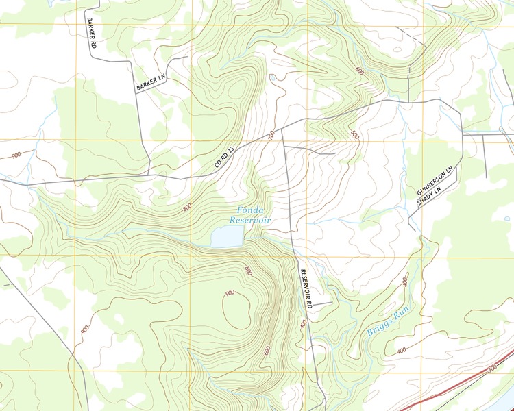
Location and geographical setting
Fonda Reservoir is located in the Town of Mohawk, Montgomery County, New York, near the hamlet of Randall and west of the Village of Fonda.
The United States Geological Survey identifies the reservoir as geographic feature 950364, at approximately 42.938869° north latitude and 74.456806° west longitude, with an elevation of about 604 feet.
The reservoir is associated with the Briggs Run watershed, part of the drainage system that ultimately flows into the Mohawk River.
Although located outside the incorporated Village of Fonda, the reservoir plays an important role in supplying water to the community.
The Village of Fonda water system
Fonda Reservoir is an important component of the municipal drinking-water system serving the Village of Fonda and portions of the neighboring Town of Mohawk.
Village water-quality reports identify the system's source as Briggs Run Reservoir, a surface-water supply that undergoes filtration, disinfection, and other treatment before distribution to customers.
The water system serves households, businesses, public institutions, and other facilities throughout the service area.
Among the institutions dependent on the municipal system are Montgomery County government facilities, commercial establishments, and the Fonda-Fultonville Central School District.
The reservoir therefore represents an important part of the public infrastructure supporting the community.
Reservoir construction and maintenance
The Fonda Reservoir Dam is an earthen embankment structure associated with the village's water-supply system.
The National Inventory of Dams identifies the present dam as having been completed in 1972, although the history of earlier reservoir structures and improvements has not been fully established.
The dam is classified as a significant-hazard structure because of the potential consequences that could result from a failure. This classification describes possible downstream impacts, not necessarily the present physical condition of the dam.
In recent years, the Village of Fonda has undertaken engineering evaluations and pursued improvements to its water infrastructure.
These efforts have included reservoir and dam assessments, water-treatment improvements, distribution-system upgrades, and planning for the long-term reliability of the water supply.
The village's public reports document the continuing importance of maintaining the reservoir and related facilities.
Fonda Reservoir and Old Fonda Reservoir
An important geographic distinction appears in United States Geological Survey records.
The present Fonda Reservoir is identified near Randall at approximately 42.938869° north latitude and 74.456806° west longitude.
A separate feature named Old Fonda Reservoir lies farther east, at approximately 42.952072° north latitude and 74.404487° west longitude.
Both features appear on USGS topographic maps of the Randall quadrangle.
The naming suggests a historical relationship between the two reservoirs, but the available records do not establish precisely when the older reservoir was built, when its functions changed, or how the two facilities developed in relation to one another.
They should therefore be treated as separate geographic features rather than alternate names for the same water body.
Connection to the Fonda family
The reservoir's connection to the Fonda family is geographical and indirect.
The Village of Fonda was named for Douw Jellis Fonda (1700–1780), an early Mohawk Valley settler and trader associated with the former Dutch settlement of Caughnawaga.
The municipal reservoir subsequently acquired the name of the village whose water system it serves.
No evidence has been identified that the reservoir was named directly for an individual Fonda family member or that the family participated in its construction.
Nevertheless, the reservoir represents another example of the continued use of the Fonda surname in the geographical and institutional history of Montgomery County.
Its importance is not primarily as a family property or historical monument, but as an essential public resource serving the community that bears the family name.
Sources and references
- Fonda Reservoir — geographic feature record, MyTopo: Mapped feature and geographic listing for Fonda Reservoir.
- Old Fonda Reservoir — geographic feature record, MyTopo: Separate mapped record for the historic Old Fonda Reservoir.
- Village of Fonda — letters of support requested: Municipal notice concerning village projects, retained as contemporary local context.
- Village of Fonda — 2024 annual water report: Official water-system report for the village.
- Village of Fonda — current projects: Current municipal project information, useful for water infrastructure context.
- Randall quadrangle — USGS topographic map (2016): Topographic reference for the reservoir’s location and nearby landscape.
- Fonda Reservoir Dam — dam inventory listing: Identification and inventory details for Fonda Reservoir Dam.
- USGS-derived Geographic Names record: Fonda Reservoir — name, location, coordinates and feature number.
- Village of Fonda: 2024 Annual Drinking Water Report — the Briggs Run water supply and treatment system.
- USGS Topographic Maps: cartographic source and reuse information.